

Rownd Mynydd Du (Black Mountains Round) Route recce - 7 central summits
- ultramadlizzie

- Feb 7, 2023
- 10 min read
Updated: May 19, 2023
Date: Thursday 19th January 2023
Strava says: 17.65 miles
Elevation: 2,854 ft / 870 m
Weather: Sunny & cold
Start: Cadwgan car park, nearest postcode NP7 7LY
Route type: Recce, circular
Conditions: Hard snowy ground, ice in places
Website link: Rownd Mynydd Du (Black Mountains Round)
Describe the route in three words: outstanding ridgeline running

7 central summits of the Rownd Mynydd Du (Black Mountains Round) including Waun Fach & Rhos Dirion - Route Recce
My plan was to start my run today at around 10am, an hour earlier than the first route recce the day before. As I headed towards Cadwgan car park, the road became less and less used, therefore the snow and ice on the ground was more prevalent. My car is not renowned for its suitability for anything other than a dry tarmac road so as each minute passed, I felt relieved to be slightly nearer my destination. Running through the back of my mind I was accessing the real possibility of having to park some place else and run to the start. I was also wondering about what I would do if my car was not capable of driving back the way I had come. I’ll deal with that tricky situation later I thought, whilst wondering how many days I could survive on the food and water I had with me. I drove very slowly, my theory being that if my car went out of control, the slower I was going, the less damage I would cause to someone's wall / fence / hedge / my car. I reached a dip in a hill and spotted a truck wheel spinning part way up the hill.

The sat nav informed me that the car park was just at the top of this ice laden hill. I turned my engine off, unsure of how long I should wait. A few minutes passed and I got out to ask if there was anything I could do. Two workmen sat in the warm cab with the tiniest of dachshunds who was delighted to meet me and be made a fuss of.
Their Welsh accents were very strong, but after the third attempt I realised that they were asking me if I was the geologist. No, I’m just here to park and run.
Their colleague was a little further up the hill in the same wheel spinning predicament. I walked back to my car just as another car turned up. I asked him if he was the geologist, no, he was here to park and walk. He pointed at my Hart Road Runners hoody that I was wearing, “Is that Fleet?” “Yes.” I replied, “I live near there.” he said. “Oh really? Whereabouts?" “Aldershot.” came the reply. Crikey, what a small world. I immediately released the luck of this situation. If my car were to get stuck in the snow, surely I could catch a lift home with this guy?! We decided we would turn our cars around and park on the side of the road, he mentioned there was a car park a few hundred metres back the way we’d come. He was here to walk with his mum, whilst his mum’s partner (Colin) would wait for them in the car. They would be around 4 - 5 hours. I felt incredibly reassured that if I could not get my car out of this road later on, then help would not be far away. Just as we decided on our plan, a Land Rover with a trailer turned up (the geologist?!) as well as an enormous truck.

By now, all the workmen from up the hill had got out to admire my car. They agreed that me turning around was a good idea, and if I got stuck in the snow, there was enough muscle to push me out. So, the 50 million point turn in the snow and ice began. I’m ashamed to say, that at first I forgot to take my handbrake off so my car just wheel span - opps. The men pushed, I casually released the handbrake and kept it revved in reverse, no need for me to do anything really as the car just spun around in the snow with the men pushing it, easy! It would have been a massive issue however if I had been on my own! I parked up and got myself ready. As the gps kicked in on my watch, I realised that the car park I was now parked at, was the correct one all along! I hadn’t spotted it in the snow and also the sign had fallen down. I finally set off on my adventure at 10.48am, way behind schedule but pleased to know that as long as I was around 4 hours, I knew where to get help from if needs be.
The first part of this route is up a track alongside a stream. The track bears around to the left and you could nearly miss the steps and footpath heading straight on up. I had to clamber up through bracken alongside a tree line, there wasn’t an obvious path but it certainly was the right way. There was a right angle turn just as I was beginning to despair thinking I’d be fighting through bracken and tree routes for ages. This was another clear footpath, leading to a gate where I turned left and then right almost immediately. This climb is fairly steep, wild Welsh Mountain ponies looking at me mid grass munch. It’s a kind of ‘pick your own route’ situation for a while as there are a number of sheep trails that could be taken. I finally reached a footpath which skirts around the hill, upwards and over. I reached Bal Mawr - 607m at 11.20am and now knew I had an endless amount of ridge running. What a joy this was going to be!

The whole route to Rhos Dirion, just over 5 miles of it, is ever so slightly uphill. I pondered that perhaps once on the other side, the ridgeline would perhaps be ever so slightly downhill? I passed a couple of hikers, I kept looking all around me to soak in the spectacular views, I could easily see the ridge that I would be running back along in a few hours time. I stopped here and there to take some photos and just stand there and say, “WOW”!

The summits are easily ticked off along here as there are no significant up or downs. I reached Chwarel Y Fan - 670m at 11.41am.

It was an absolute beauty of a day, more so because of the snow on the ground and the blue sky. I didn’t feel cold though because of the bright sunshine. I could see a guy in the distance with an orange bag on and decided I had to pass him before I reached the top of the next hill. I saw a Cliff bar wrapper on the floor and stooped to pick it up and put it in my pocket. As I neared the guy with the orange bag I realised he was a soldier. He was to be the first of many I saw as they appeared to be on a fairly grueling exercise, that’s if their faces were anything to go by! I passed him before the brow of the hill (small wins) and ticked off another summit, Twyn Talycefn - 702m at 12.17pm.

This is where the soldiers seemed to be reconvening as there were loads of them queuing to report to someone at a tent.

I reached Rhos Dirion - 713m at 12.28pm where the soldiers were turning right. I knew I was heading left here but got my map out to remind myself of what the route looked like. I wondered that it might be colder on this ridgeline as some of it was not in the sunshine. I had packed a proper coat as I was nervous I wouldn’t be warm enough today. It turned out I didn’t need it after all, but I am very glad that I took it, if the sun had gone in, I would have needed it for sure.

I needed to come off route for a little while to then pick it back up again, the two sections of the route today I ran in the right direction but in the wrong order (it was the only way to do it and doesn’t matter about the order). The Dragon’s Back looked spectacular, I have run along this once before, this was with Hannah for the Blacks to the Beacons and in a downhill direction. I would be running it uphill on the Round and plan to do it as part of my next recce. It looked fantastic with the sun casting light and shade, the snow spattered about, I stopped at 12.43pm to send a photo to Hannah in the hope she would recognise it.

I reached this cain at 12.54pm and feeling a bit peckish I had something to eat whilst heading towards Waun Fach. I put my second pair of gloves on as it was a bit cooler on this side.

I could just about see the mound in the distance that marked Waun Fach and wondered if I’d need to get my coat out as the weather looked totally different over there, and very, very cold. There were some more soldiers heading down the hill towards me, I asked one of them if it was windy up there and he remarked it was surprisingly alright. I decided to leave my coat in my bag for the time being. When I got to Waun Fach- 800m at 1.08pm, there was no wind at all.

There was another tent with a load of soldiers milling about, a soldier who appeared to be the leader asked me about my run and how far I was going, as I was leaving I overheard him say, “it’s minus 8 on the bridge”… I wondered if that was the temperature here? It certainly didn’t feel too bad, although I did have double gloves on, I needed them! As I headed away, it was pretty much white out conditions and a young soldier asked me if there were a load of people that looked like him nearby. Yes, don’t worry, you’ll see them in a few seconds!

I was out of the cloud before I reached Pen Y Gadair Fawr - 800m at 1.28pm which is just a rock pile.

It was around here I picked up some fox tracks. I was to end up following the tracks for around about 4 miles.
The fox had selected a fantastic route, avoiding all of the iced over puddles, I know this because the couple of times I deviated from the fox tracks, I lost my foot through an iced over puddle!
Lesson learned, I stayed on the fox’s line! There was an interesting bit which I believe was shortly after Pen Twyn Mawr - 658m (I didn't take a photo) where the path takes you very steeply downwards, I felt like I needed to be super cautious due to the snow and slippery ice and the odd rock here and there, hopefully in warmer weather I can be quicker going down there.

I was heading for my final summit of the day and I could tell by the temperature, the reduced snow cover and the trees that this was much lower down. I had also been right about the gentle up / down, in fact, you only need to look at the elevation of the summits to see that this ridgeline is heading downhill whereas the elevation on the previous ridge heads uphill.


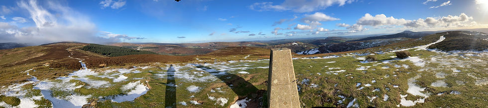
I could see a mound in the far distance which I thought might be Crug Mawr but it came along sooner than expected, I rounded a corner and could see the trig point quite clearly. I arrived at Crug Mawr - 550m at 2.32pm and wow, what an awesome view point! It looks quite indiscreet as you are heading towards it but once there, you have the whole of the Black Mountains laid out before your eyes, another one of those quite literally breathtaking views where you can’t help but just exclaim out loud.

With a mixture of joy for having had such a successful run but sadness as I knew it was my final summit of the day, I started heading down towards the car. It’s worth noting that just after the gravestones, you pass through a gate then immediately on your left is another gate on a fence line. The gpx takes you along the fence line so it is unclear whether you should pass through the gate or not. There is no need, the path is much better on the right hand side of the fence. If for whatever reason you do go through the gate, then there is another gate further down so you can come back through again.


I headed down a gravel track, through a forest and through a farmhouse (footpath takes you past and down the side of the building), I did think as I was running along the lane what a long driveway and to live here you most definitely need a suitable vehicle. I came out onto a lane, down and down I went, makes you realise just how high the route is! I arrived at my car where Colin was sat in his car reading the paper. We had a quick chat and I prepared myself for the drive home. A fantastic day out.


What’s in the snack pack?
Philadelphia cheese and cucumber sandwich
Luchos guava square
Natural bar
Mixed nuts
Sugar coated stemmed ginger
Mints
2x 500ml bladders water - with Phizz
Spare 500ml bottle water
Spare gloves
Salomon Bonatti waterproof over mittens
Inov 8 Trailshell waterproof jacket
Long sleeved spare layer
Vasaline
Harrier Helvellyn Carbon Z-Poles and quiver
Petzl e+lite head torch
Whistle
Survival blanket
OMM Halo waterproof trousers
Save the Duck ‘down’ jacket
Fully charged mobile phone
Harvey’s map
Silva Expedition 4 compass

What I wore: Saucony Peregrine 12 ST, Garmin Fenix 6 Sapphire, buff, Sweaty Betty power leggings, Stance socks, Montane long sleeved top plus Montane merino long sleeved top, hat, gloves, Dirty Girl gaiters, Salomon Adv Skin 12 running vest.

Lead up: The day before I ran a 17 mile recce from Sugarloaf, today I wondered if my legs might be a bit tired but they were fine.

Morning preparations: A breakfast of overnight oats and a cup of tea, I left my friend Pippa’s house in Rogerstone at 9am.

Summary
I really feel that I need to be careful when mentally preparing for this Round, I think I could easily lull myself into a false sense of security by thinking that this `round is easier than the Gwynne-Harris Round as it has 1000 m less elevation and is a little shorter. However, I have a sneaky suspicion that those beautiful long ridgeline sections are actually going to be really mentally quite challenging, the constant terrain technicality and direction changes on the Gwynne-Harris keep you very busy and mentally stimulated, the long ridelines on Rownd Mynydd Du (Black Mountains Round) may become a time when thoughts wander to unhelpful places.

Lessons learned
Always be prepared: I am so glad I packed a warmer coat, although I did not need it, it would have been a literal lifesaver if the sun had gone in or I had got into difficulty and needed to be stationery for some time.

Results
Elapsed time: 4 hr 11 m 10 s
Strava route: https://www.strava.com/activities/8417816158


Comments