

Dragon’s Back Recce - Day 2
- ultramadlizzie

- Jun 27, 2021
- 15 min read
Updated: May 21, 2023
Date: Monday 14th & Tuesday 15th June 2021
Official miles: 36.66 miles / 59 km
Strava says: 39.95 miles / 64.29 km
Elevation: 10,827 ft / 3,300 m
Weather: claggy to start then blue skies & hot
Start: Nantgwynant, Wales
Finish: Dolgellau, Wales
Route type: A - B, multi day (2 days)
Conditions: rocky, boggy, mossy, wet & dry
Website link: Montane Dragon’s Back / Ras Cefn Y Ddraig - The World’s Toughest Mountain Race
Describe the route in three words: high, scenic, epic

Recce report - day 1
We had a short road run to start our adventure and I was aware of an annoying rubbing in the small of my back. We made a right turn up a track and I said to Kev that I really needed to sort out aforementioned annoying rub. Turned out my extra bladder was the wrong way round and the tube was rubbing me. It's a very good job I flipped it around, I found out later on in the evening it had caused a massive blister and friction burn, that happened within 10 minutes of starting.
If I had ignored it, then later on, that rub would have most likely caused me to call it a day and stop running.
Issue now fixed, the track we were now on was where the ascent started. I knew that this was going to be the most amount of elevation I have ever done, over terrain I am unfamiliar with and lacking experience in so it was great that we were hitting the up immediately - this was exactly what I was here for! The ground was a mixture of rocks and long grass, there was a winding track but we were using Dragon’s Back race director Shane Ohly’s gpx file - never mind the track, we were taking the direct route up! We were a bit stop-start as Kev’s watch kept wanting to calibrate the compass and then it kept changing its mind about which way we were going but it finally got sorted and we were off. The scenery from the get go was phenomenal. We passed the odd derelict building, boundary walls (which we would be seeing more of) and we often crossed or ran alongside waterways. It was claggy so we could not see far into the distance which meant we were relying heavily on the gpx taking us the right way rather than looking for visual markers.


We continued gaining height, and the long wet grass underfoot became more and more littered with rocks until we found ourselves making a steep ascent up mount Cnicht (680 m) via a rocky slaty channel. This is completely new terrain for me and I found it quite exciting, there is no guarantee that what you put your foot on will stay in place so I was thinking a lot about my balance, not over stretching (taking short strides rather than long) and using my hands where necessary to make myself feel more secure.

This continued and we got near a peak, we knew the weather would blast us as we rose over the top so we both stopped to put our waterproof jackets on. Good job as the moment we rose over the peak the wind and rain was apparent! We had to scramble up and around the rocks. I was now completely out of my comfort zone. I kept calming my mind, focusing on the few feet in front of me, keeping my head bowed slightly. I did not want to look down and I was rather grateful for the clouds preventing me from seeing just how high we really were. I didn’t feel nervous, I didn’t feel scared. I just felt very focussed on the job at hand. I expect my heart was probably pounding even though from the outside I was behaving so calm. I felt as though if I gave too much thought about what I was doing, I might begin to panic and that wouldn’t be helpful. There are no emergency exits or side doors on the Welsh mountains. We’d go from moments of feeling as though we were teetering on the edge of the mountain to larger rocks where I felt very safe and secure. We reached the top and I felt absolutely elated. I had just completed my first mountain summit and felt exhilarated!


We ran along the ridge and I shouted to Kev, “I’m having my moment!”. The day before I told him I couldn’t wait to find out what it felt like to run along the ridge after scaling the mountain. I felt like a Dragon, I was flying high with a fire burning within!
With the Cnicht summit behind us, it was time to head for the Moelwyns. We had to make quite a steep grassy descent, by steep, this was unlike any descent I have done before, I was using my hands quite a lot as I clambered down, in the end I found out I was really fast if I adopted a glute bridge position and crawled down that way (stomach to the sky), all those tricep dips Hannah makes me do at Blaze came in super handy! We passed the beautiful lake Llyn Cwm-y-foel and it didn’t seem too long until it was time to head upwards again.
Climbing Moelwyn Mawr (770m) wasn’t such a challenge. Even though it was higher than Cnicht we were not starting as low. The terrain was much easier too, more grassy rather than rocky. When I say ‘easier’ just remember, these are still mountains with a level of elevation I am unfamiliar with! Calf and thighs were burning!


To reach Moelwyn Bach we had to make a steep rocky descent, I really enjoyed clambering down, focusing on each and every rock, how I would grip it with my hands and where I placed my foot. I took a moment to admire the view and realised I was currently halfway across a ledge! Focus, take a deep breath, don’t think too much and carry on.

We were soon down and making our way up Moelwyn Bach (710m), this was a very steep path but an easy one to navigate. Once at the top, Kev realised he’d left his map on a rock at the bottom whilst having a pee. He left me sitting by a rock out of the breeze and in the sunshine whilst he went all the way down to get it. I must admit, I had a lovey time up there! I ate some lunch, admired the view, uploaded an Instagram story and put some suncream on my face. In no time at all, Kev was back with me, happy to have his map safely tucked in his pocket. He was not best pleased to discover that Moelwyn Bach is an out and back checkpoint so we had to go down again and pass the very rock he had just visited. At least he can say he has done hill reps up Moelwyn Bach!

With the day’s mountain climbs and their extreme elevation behind us, it was in theory going to be quicker progress. The clag had lifted and the sun was blasting us, revealing the scenery that was further afield. We had an enjoyable time zigzagging along the route, a few nav errors here and there but nothing too drastic. It was easy enough to get back on course. I love the ladders which are there to propel you over the boundary walls.

We crossed a railway which we would be seeing again later and continued over grassy and boggy terrain. We came to the railway once more and this time we were to run alongside it, pausing to take photos at the quaint Dduallt train station.

We carried on and could hear a steam engine in the distance, how exciting! Our route lead us away form the railway then back towards it again, the steam engine was getting closer! We stopped and waited for it, me madly waving at the passengers who I am pleased to say waved back. There was a short downhill tarmac section which showed me that I seriously need to work on my downhill technique, Kev was off like a whippet! I couldn’t belive how fast he went. I tend to sit back a bit on my hocks, Kev told me to lean forward and relax into it, let the gravity carry me. Easier said then done though!

We passed through a gate and Kev recognised the grassy ridge from one of the many Dragon’s Back videos he has watched. It was an enjoyable, fast easy section. We came out onto tarmac and had a long uphill road section next, passing through a village which would be somewhere you could potentially pick up extra water and food. We ran the sections where the hill took a break from its steepness but this whole section was mainly a time for fast walking, chatting and eating.

There wasn’t too much distance to cover now, but there was an awful lot of ferns and rocks, it was going to be very slow go from here to the end. I couldn’t find a technique that could make me cover the ground any quicker than a purposeful walk. It was enjoyable though, I wonder if this section could be a bit frustrating in the race, it’s so close to the drop bag check point but so slow.

We came to the top of the hill and the views below showed that of a campsite. That was it! That’s the checkpoint! Kev was pretty quick down that slope, it was steep and rocky and I lacked the skills to go down it as quick as he did, it was wonderful to pop out on to the road and take the short uphill at a fast run into Cwm Bychan campsite, checkpoint 7 of the route and where the drop bags will be. Our part 1 of the Dragon's Back Day 2 recce was complete.

We had an enjoyable 5 mile run/walk into Harlech where we had booked rooms at the Castle Cottage Inn. I highly recommend them.

Recce report - day 2
We had a leisurely start, breakfast at the B&B at 8.30am and then a taxi ride back to the Cwm Bychan campsite - not exactly replicating the conditions of the Dragon’s Back!

We left Cwm Bychan campsite at about 10am and headed straight up the Roman Steps. The sun was shining (I had lathered the suncream on, as I was a bit red from the day before!) and we moved at a very enjoyable pace up the steps, chatting about the day ahead and Kev enlightening me about VO2 max and how heavy breathing during exercise develops your mitochondria, which are your energy factories.
The steps ran out and we were greeted with a mound of rocks which turned into a mini mountain. The gpx seemed to want us to head straight on up and over so we started the climb. Admittedly, this was much more stomach churning than yesterday’s accent of Cnicht but I remained calm, and concentrated on my hand and foot placement, taking care not to look down or too far ahead. We reached a ledge where we had a lovey view of a path below skirting around this mountain, that was where we were supposed to be. This was a very costly nav error, not only in time but also risk. Kev is not only a qualified coach, but head coach at running club, and seasoned mountain ultra runner, I could not have been in safer hands. I pushed the fear back inside me that kept wanting to creep up and and carefully side stepped around the ledge.

Kev’s top tip of, “Just hold on to the heather and don’t look down” made me laugh.
Once safely around the slightly terrifying ledge we could see our decent downwards, not nearly as stomach churning as what we had just done but very steep nonetheless and I knew it would take me an age to carefully tip toe down it, I adopted my new glute bridge crawl technique which worked a treat. Kev was at the bottom in no time and took a picture of me. That picture does not sum up just how steep that thing was!

Now back on the correct path, it was an easy one to run along, skipping and jumping over stones but it was short lived, it was time to start climbing the first real mountain of the day, Rhinog Fawr (715 m). We passed the lake of Lyyn Du and our climb really got going.

It was super hot but I was really pleased to find that it was absolutely doable. It was indeed steep, but there were plenty of places to put feet and hands, it zig zagged up and I was able to maintain a consistent pace. I had wondered if my legs would start screaming at me and seize up but they didn’t, they were quite happy to keep sending me upwards. I remarked how some of the steps I had to take didn’t seem so high, but when I found my knee close to my mouth I realised just how high they were and how rapidly increasing our elevation was.

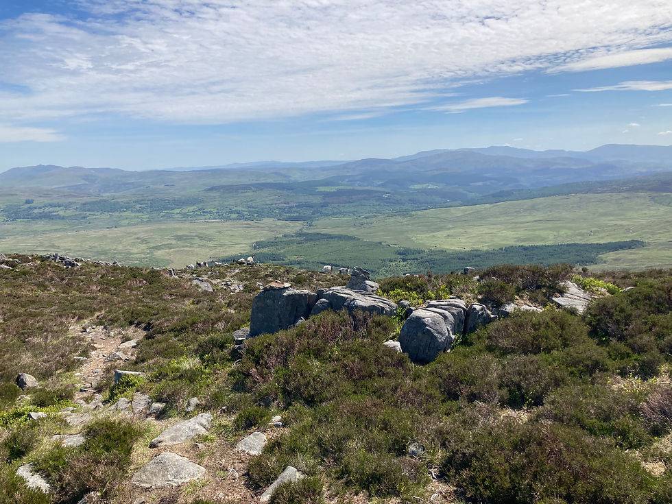
We reached the top and had spectacular views of Lyyn Du and around.


It was time to start heading down again. The bottom was marked by one of the many ladders to get us over a boundary wall and then it was time to head straight on up the next mountain, Rhinog Fach (706 m). I chuckled to myself, this route is unforgiving, as soon as one mountain is done, it's time for another!
I wondered if any of the accents would be as tricky as our first one of the day, the nav error mountain, but luckily this one seemed like it would be an enjoyable one too. After a long hot climb, we made it, just as a walker with trekking poles summited from another side, he looked so casual, I like to think that he’d taken an easier path as I don’t think he’d even one bead of sweat on his forehead!
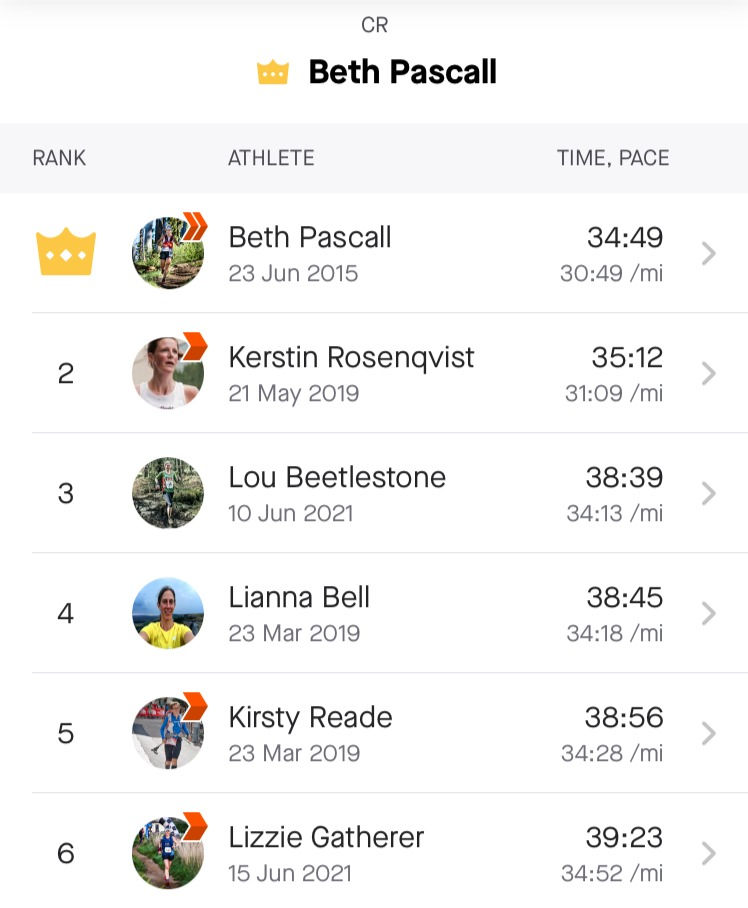
It turns out that I wasn't too shabby making that climb as I made it to a Strava segment leaderboard. I feel honoured to have my name listed so near to Beth Pascall's!
The thing is with getting to the top of a mountain, you then have to go straight back down again, it seems like a huge amount of time is spent getting to the top to admire the views for around 15 seconds before heading down again! Initially the decent of Rhinog Fach was an easy one, we passed a herd of mountain goats and then happened upon a rock fall field, only one route available, and that was straight down.
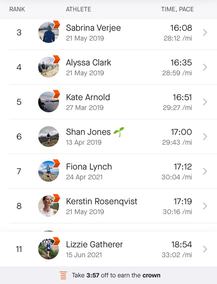
My word this took FOREVER to get down! It was not necessarily hard, or scary for that matter. I just felt I needed to be very careful as every rock moved, and every rock posed a potential ankle turning injury. I think it took us around 55 minutes to get down. I’d love to see the likes of Sabrina Verjee coming down and see her technique and how fast she can do it!

After the rock fall of Rhinog Fach it was already time to start heading up again, the next mountain top was Y Llrthr (750 m) and woweee! This was awesome! I felt like I was in the Dragon’s Back promo video, this is the classic mountain top running which made me want to sign up to Dragon’s Back in the first place! (Having then watched the promo on Day 1’s Crib Goch I immediately decided I didn’t want to sign up after all). I felt absolutely epic running along here.
I do love that having run this route my name gets to appear near some legends' names! Love that I'm just a few minutes behind Sabrina Verjee!
We stopped briefly for a lunch break shaded from the hot sun by a boundary stone wall which sprawled endlessly into the distance.

The route took us along the wall down a hundred metres or so past a small lake and along the majestic Crib-Y-Rhiw.

This was a proper runable path now, it was a grassy route, littered with many stones but the past day and a half had certainly taught me to pick my way a lot quicker along technical paths such as this. I was really pleased at the pace, I was mostly looking down though as didn’t feel confident enough to look too far ahead in case I tripped over a rock. I glanced up and noticed that Kev was zooming off into the the distance at the speed of a thousand gazelles. Oh deer (sorry, had to do the pun!) I hope he was checking to see that my disappearing dot was still behind him! He bobbed up and down, in and out of view as the path rose up and down. There really was only one way to go along here though so no matter that he was so far ahead. It was brilliant for me to experience the difference between a seasoned mountain trail runner and a virgin mountain trail runner. We were heading steadily up again, towards the checkpoint at Diffwys (750 m). Kev said it was an out and back checkpoint and there was no need for me to go to it. I started following him but then thought better of it, Kev would be better off if I had a sit down and a rest, in the hope that I’d be better at keeping up with him after said rest. I sat there on the top of the Welsh ladder in the glorious sun, my eyes eating up the views.

I had something to eat and drink and it didn’t feel like too long until I could see Kev skipping down the mountain. Opps, that wasn’t a skip, that was a bounce! Ok, maybe the most experienced runners take tumbles! Without skipping a beat, he was back upright and running down and towards me. That was all the major elevation of the route done now, it was time to start picking up the pace and heading toward the final checkpoint at Dolgellau.
The rocky yet runable path continued down, Kev said that we would reach a forest. It was bizarre, I felt like I was in a computer game transferring from the mountain zone to the forest zone. There was a style, and immediately over it the forest began! We zoomed through the forest and came out onto a track, we were really enjoying the easy downhill, perhaps a bit too much as we took the wrong path! We retraced our steps, got back on the right path which was a gravel track which then turned into tarmac road. Easy running now. I couldn’t believe how great my legs felt after all the climbing and clambering they had been doing. The last 4 miles of the route we were averaging 9 minute miles, not bad I felt!
We came to the most stunning bridge, Penmaenpool Toll bridge. We got to the other side and discovered that pedestrians need to pay a 30p fee each. Luckily they accept card payment, we’d have been in a quandary otherwise! The bridgemaster explained that the Dragons do not pay a fee on the day of the race, the Dragon’s Back organisers take over the running of it out of hours. Good to know. You’d be really annoyed if you were close to cut off time and couldn’t locate your 30p!

The last part of the route was an easy footpath along the Mawddach Trail. Our lovely taxi driver Stephen was waiting for us at the end. And that was it, Dragon’s Back day 2 recce complete! And what a memorable experience! I am a baby dragon who is in complete awe of the Dragon’s who partake in this epic adventure.
What’s in the snack pack?
2x red pepper hummus, guacamole, cheese wraps
2x bags Quorn cocktail sausages
6x Nakd bars
2x bags Jelly beans
2x bags fruit & nut mix
2x malt loaf snack size
Dextrose tablets
Sugar coated stemmed ginger
Mints
2x 500ml bladders water - 1 plain, 1 with Hi 5
2 litre bladder with Hi 5
Hi 5 tabs for second day
Gloves
Hat
Innov8 Trailshell waterproof jacket
Long sleeved spare layer
Vasaline
Safety pins
Compeed, plasters, surgical tape, spare socks
Harrier Helvellyn Carbon Z-Poles and quiver
Head torch
Phone
Charging cables for iPhone, Garmin with a plug
Portable charger
Whistle
Survival bag
Clothes for day 2 (leggings, sports bra, vest, pants, socks)
Evening essentials (toothbrush, toothpaste, hairbrush, pants, shorts & tee shirt for evening wear/sleep)
What I wore: Saucony Ultra ST, Stance socks, Garmin Forerunner 35, buff, Sweaty Betty power leggings, Sweaty Betty athlete vest, Dirty Girl gaiters, Salomon Adv Skin 12 running vest.
Lead up: as this was not a race, I did not do any particular preparation. I had done a 40 mile walk on the Friday, so took Saturday and Sunday as rest days.
Morning preparations: I ate overnight oats on the first morning (oats, greek yoghurt and frozen fruit left to seep overnight) and had a fantastic hearty cooked breakfast at the Castle Cottage Inn in Harlech on the second morning. I did around 5 minutes stretching before each day.
Summary: A phenomenal experience, one that I feel privileged to have done. This was a training session I would not have been able to do under my own steam. Having Kev as the organiser and guide made it extremely enjoyable (and safe), I remarked to my husband that the route we did would not have been one I could have done with anyone else, it would have been dangerous as I had no previous mountain experience. Seeing the route first hand showed me that those who do take on the Dragon’s Back, can’t do so on a whim. You must train for this race, not just in fitness but in navigation and mountain survival. Do not enter this race if you have no previous mountain experience.
Lessons learned
Have the correct gear and supplies, plan for all events. I felt like I had an enormous amount of food and water with me but actually I got it just right. I didn’t run out, but I was low on food and water by the end of each day, if we had have got lost, I would have had enough supplies for a few extra hours. The weather can change so dramatically too, I was so grateful for the waterproof jacket which I did need, as well as the warm layers (top, hat, gloves) which would have been necessary if I had have got injured.
Mountain running is entirely different from any previous terrain I have done. I learned the hands on knees technique for going up hill, I developed my own glute bridge crawl for coming down steep descents, and I am certainly more sure-footed and confident on this technical terrain.
Deal with issues immediately and observe the rule of three. If you have thought of something three times, then you need to take action. My friction rub at the very start could have ended my journey if I had not dealt with it.
Don't forget to put suncream on!

Results:
Elapsed time day 1: 9h 38m 59s
Elapsed time day 1 finish to B&B: 1h 25m 43s
Elapsed time day 2: 6h 18m 03s


Comments